
I hiked Section A of the Pacific Crest Trail in Southern California with my friend Mike in April, 2022. We started at the US-Mexican border on 8 April 2022. We hiked about 110 miles in six days on some interesting desert terrain. Here’s the plan:
- Campo to Lake Morena – 20 miles
- Lake Morena to Desert View (Mount Laguna) – 22 miles
- Desert View (Mount Laguna) to Sunrise Trailhead – 17 miles
- Sunrise Trailhead to Scissors Crossing – 18 miles
- Scissors Crossing to Montezuma Valley Road 23.5 miles
- Montezuma Valley Road to Warner Springs 8 miles (Leg 8)
Mike did our route planning. A book that he used was Hiking the Pacific Crest Trail: Southern California: Section Hiking from Campo to Tuolumne Meadows by Shawnté Salabert. I found the trip descriptions very useful in this book and wrote a book review: Practical SoCal PCT Section Hiker Guide.
Setting Off
We did a car shuttle every day, leapfrogging up the Pacific Crest Trail (PCT). We placed my 4Runner at Lake Morena, where the PCT comes out near the state park. We then drove Mike’s rental car back to Campo, parking at the Camp Lockett Event and Equestrian Facility (CLEEF) near the PCT hikers campsite. I used my Garmin InReach to let Mary Ellen know we were starting our hike. It was great to see her respond, it made us both happy we had two-way messaging as needed. I’m new to this technology, it worked well over the six-day trip.
We kibitzed with a couple of hikers then walked about ⅓ of a mile to the monument marking the southern terminus start of the PCT at the US-Mexico border. Fellow hikers snapped a photo of us. I took another photo that shows the border wall stretching into the distance. Next, we talked to two folks from the PCTA – they were handing out tags for thru hikers. Signed the log book and headed north.


Hiking was easy in the cool morning. We encounter a number of PCT thru-hikers; they plan to walk the entire 2650 miles (4270 km) of the trail. In comparison to these ultra-hikers, we are sprinters. Mike and I are hiking about 4% of the PCT in the next six days. I realized that only about 1 in 5 of the thru-hikers we see starting near Mexico will make it to Canada. (A range of 14% to 34% of thru-hikers made it, based on a 7 year survey by thru-hiker “Halfway Anywhere” It’s great to talk to these intrepid souls. There were people from around the US and Europe, especially Germany.
We are heading across rather a green desert chaparral as Mike pointed out to me. So, what is Chaparral? According to the California Chaparral Institute:
“Chaparral is California’s most extensive, native plant community, dominating foothills and mountain slopes throughout most of the state. …. Chaparral is a semi-arid, shrub dominated association of sclerophyllous (hard-leaved), woody plants shaped by a Mediterranean-type climate (summer drought, mild, wet winters), and infrequent fires (with natural intervals between fires being 30 to 150 years or more).”
So, I have a new area of nature to learn about. I’ll try to write up something of my natural observations of the Chaparral I saw along the PCT in a separate post.
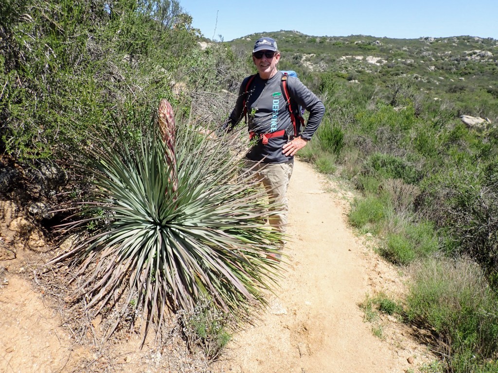
I am pleased to see my first yucca coming into bloom. There’s Mike standing next to a yucca to provide scale. When this species of yucca is in full bloom, the flowering stalk (scape) is about 10 feet tall. It’s covered with cream-colored flowers. We saw many more yuccas in bloom on our next six days of hiking; they never failed to amaze me.

As we sauntered along, we came across many signs telling us how far to the northern terminus (and how far we had journeyed).

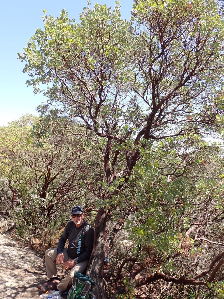
Manzanita trees made for a nice place for a break. As we moved towards noontime, it started to heat up. We made sure to keep up with our nutrition and hydration.
I caused us to add a bonus mile and a half as we descended into Hauser Canyon at about 12 miles into our day. We were on a road and I missed an important turn. I was annoyed with myself because I had just checked our location using the FarOut (formerly Guthooks) app of the PCT.
We had a little challenge near the end of the hike: climbing out of Hauser Canyon on a sunny, warm afternoon. We were climbing over the ridge shown in the photo.
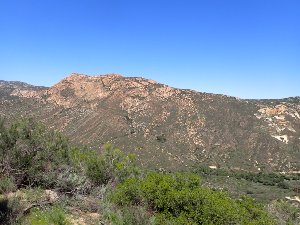
“The climb out of Hauser Canyon is serious business – you face over 1000 feet of elevation gain in about 1.5 miles. Dehydrated, overheated, and underprepared hikers are rescued near here every single years sadly, one hiker died after making the grueling climb in 2014, Consider timing your ascent for a cooler time of day, make sure you’re hydrated and ensure that you eat enough to keep your motor running.” Hiking the Pacific Crest Trail: Southern California by Shawnté Salabert
We made it over the ridge. I did have to stop for a rest in some shade part way up. I could see the heat was having an effect on me, my heart rate kept jumping above 150. We found some shade and Mike had good advice to put my feet up. After I felt rested, I gave it five more minutes to be sure I was good.

We sauntered the remaining four miles or so into Lake Morena State Park. I sent a message to Mary Ellen that we were done with our hike. We dumped our gear in my 4Runner. Next, we had a great meal at the nearby Oak Shores Malt Shop. We headed south to Campo to get Mike’s car and then back to our motel as it got dark.
I recorded our day using Gaia navigation software which indicated we had done 17 miles with about 800 feet of elevation gain. Our distance had to be more than 20 miles and our elevation gain was more than 800 feet. After the hike, I did a route plan using FarOut software. It showed the distance to be 20 miles with over 3000 feet of elevation gain.

I believe these numbers as they match the guidebook that Mike had. I am not sure what caused the discrepancy with Gaia. I carried my phone in the back of my pack in an outer zippered compartment. Anyway, lesson learned – I need to learn a bit more on how to work with Gaia. I also made a track with the Garmin InReach.
Okay, that’s the end of Day 1. Next post will be Day 2, Lake Morena to Desert View (Mount Laguna) – 22 miles

Thanks, John for sharing your PCT section A adventures. Not sure that 20 miles a day is sauntering.
LikeLike